
Photograph of Endicott Rock in 1893 from “Commission for the Preservation, Protection and Appropriate Designation of the Endicott Rock at the Weirs in the Town of Laconia, 1893
Endicott Rock dates back to August 1, 1652, and is a New Hampshire historic site.
In an attempt to settle the boundary line between New Hampshire and Massachusetts, in 1652, a party of adventurers was sent on a mission by Massachusetts to seek the northern source of the Merrimack River.

Endicott Rock monument
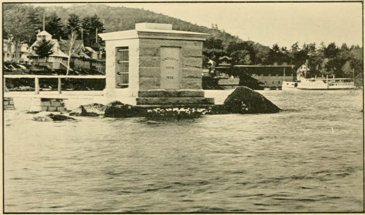
A commission was created to include Captains Simon Willard and Edward Johnson who procured surveyor services of Jonathan Ince (a student of Cambridge) and John Sherman (sergeant of Watertown), who following the guide of certain Indians, ascended the river to Aquadocton, the outlet of the lake, which was declared to be the head of the river (now the Weirs) and there they took astronomial observations, and determined the latitude to be 43 degrees 40′ 12″. This point was indicated by inscriptions on a large boulder in the middle of the outlet. This inscription, made by drills, consisting of the date, the initials of Governor John Endicott, colonial Governor of Massachusetts, who gave them their commissions, and those of the surveying party. Massachusetts claimed all the territory in the present state of New Hampshire south of an east and west line passing through that point, and lying west of the Merrimack River.
New Hampshire did not agree with these boundaries, and eventually, a royal commission was appointed to settle the controversy. It met at Hampton Falls, in this State, in 1737, the General Court of each province attending the sittings of the commission. The commission at Hampton Falls did not agree, and the question was reserved for the King in Council. The decision was finally made in 1740, fixing the province line where the State line now is.
The action of the elements (and human beings) for three hundred and fifty-four has rendered the lettering on Endicott Rock somewhat illegible. This boundary rock was unknown, or unidentified, for many years until it was “rediscovered” in either 1833 or 1846 (depending on your source).
In the late 1800’s the rock was covered by an attractive structure allowing viewing, and the rock then showed signs of wear. The site is located between the parking lot and the channel abutting Weirs Beach.
If you know of an older monument in New Hampshire, please let me know!
Janice
Source of some information: “History of Hillsborough County NH (Nashua), History of Belknap County NH (Gilford, Meredith)”
–Great Photographs and More History of Endicott Rock–
–Endicott Rock Historic Site (State of NH)-
-Inscription At Endicott Rock Monument-